- 318 Limestone Road, Āpiti
- 0212383546
- bookings@sixtuslodge.co.nz
The following are the most popular local walks and tramps, within easy reach of the Lodge, that will particularly suit school-age children and less-experienced trampers. This should be considered an introduction only, and we encourage tenants to fully research each walk before heading out.
There are large maps of the Western Ruahine Ranges displayed at Sixtus Lodge, and the Department of Conservation (DOC) provides Ruahine Forest Park map signs at the road ends of both Limestone Road and Petersons Road. Good maps of the area can be downloaded from the DOC website.
Topo50 map BL36 Norsewood, from Toitū Te Whenua / Land Information New Zealand (LINZ), is a detailed map of the region and can be downloaded, or purchased as a printed map.
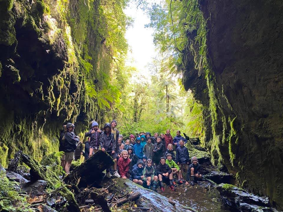
On your way to Sixtus Lodge you will pass the hugely popular Limestone Creek Reserve Glow Worm Caves. The caves are an easy walk from Sixtus Lodge (about 1km, going west) and provide plenty of opportunities for exploring and having fun, both during the day and at night, and should not be missed.
Another short walk along Limestone Road (east) leads to a bridge crossing Cone Creek, with easy access down to the stream bed for safe exploration and adventure during the day — and more glow worms at night!
For the more adventurous, head to the end of Limestone Road (east, about 1km) or west to Peterson’s Road (5km), to reach the trailheads of the Ruahine Forest Park. From there, you’ll find a number of wonderful walks and more challenging tramps through native bush and rugged terrain.
Within the Sixtus Lodge grounds, there are a number of lovely walks that take you down through native bush to Cone Creek. These short tracks are ideal for quiet exploration and nature observation.
Or spend some peaceful time in the Margot Forde Arboretum, walking among many New Zealand native trees and enjoying the serenity of this special space.
Before embarking on an excursion, group leaders should always carefully consider the weather conditions, the personal fitness of the party, and their knowledge of the skills needed when venturing into the outdoors. Furthermore, it would be regarded as foolhardy to embark on a tramp with young people — especially if it goes above the bushline — unless at least one of the leaders has completed the tramp previously. We recommend checking out Department of Conservation 'Know Before You Go' and Plan My Walk (Mountain Safety Council)
The numbers relate to entries for each walk below.
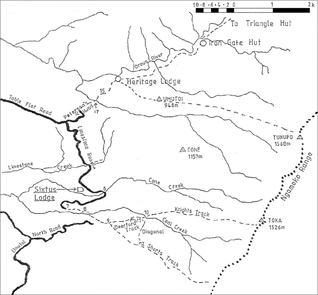
The Alice Nash Memorial Lodge Track (‘Heritage Lodge’) is owned by the New Zealand Deerstalkers’ Association (NZDA). Part of the building is always unlocked and open to the public, making it a good rest-point for groups journeying down to the Oroua River, upstream to the Iron Gate and Triangle Huts, or along the track up to Tunupo on the crest of the Ngamoko Range. Bookings for overnight use of the full building can be made through the Manawatū Branch of the NZDA: manawatuda@gmail.com A request from the NZDA: There is a Log Book in the Lodge for hunting and tramping parties to note their intentions. Please ensure that only the group leader signs the book.
The building is named after Alice Nash, a well-known identity of the district and a significant benefactor for its rebuilding after it was destroyed by fire.
Access: From the carpark at the end of Petersons Road 14. Follow the track (an old logging road) to the right and down the hill through farmland and into the Forest Park. The track crosses the Arch Bridge 17, passes an overgrown rifle range 15, and reaches a track junction about 30 minutes from the carpark. The left fork continues to the Oroua River; the right fork leads to the Heritage Lodge (less than five minutes away) and the start of the Tunupo Track.
The Arch Bridge 17 crosses theUmutoi Stream about halfway along the track between the Petersons Road carpark and Heritage Lodge. It was erected by the NZ Army Corps of Royal Engineers from Linton, replacing a wire swing bridge. A point to ponder: Why is the bridge arched rather than flat?
Note: The bridge footway can be very slippery in wet or icy weather.
The picturesque Makiekie Creek (aka Coal Creek) begins high in the Ngamoko Range. Several tributaries join it before it eventually feeds into the Pohangina River, which flows into the Manawatū River. Access: From the carpark at the end of Limestone Road 7. Follow the fenceline 8 and poled route for about 700 metres — you’ll reach Coal Creek after approximately 10 minutes.
It is possible to walk upstream along Coal Creek to the beginning of Knight’s Track at its junction with Deerford Track 10. You’ll be in water most of the way, navigating a rough and stony creek bed. The route is shaded virtually the entire way. Note: Part-way along, there is a high rock barrier that must be climbed. A rope is required (not supplied).
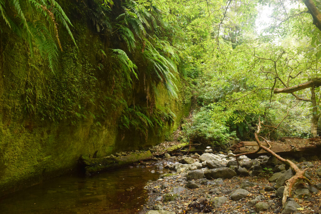
Cone Creek, another picturesque stream, issues from the foothills, passes through the Sixtus Lodge property below the terrace, then crosses farmland and flows into Coal Creek.
A walk along the stream bed of Cone Creek can be interesting and challenging. As with most streams in the area, the bed is stony and uneven, enclosed within a valley for much of the way. About an hour upstream of the road bridge, there is a narrow cutting which is difficult to pass unless you have approximately eight metres of rope. Important: Groups must return along the stream bed and must not traverse adjacent farmland.
Deerford Track is an excellent tramp for all ages and fitness levels. It can be walked in all weather conditions as it remains within bush cover, is well defined and surfaced, and involves very little climbing. Deerford Track to Makiekie Creek
Access: From the carpark at the end of Limestone Road, follow the fenceline and poled route for about 700 metres. The track slopes down to meet Coal Creek, which must be forded. After a short, sharp climb, continue to the junction with Shorts’ Track. Deerford Track continues eastward for about 30 minutes until the next fork, where it links to The Diagonal and Knight’s Track.
This is a worthwhile tramp for primary school children, offering an interesting and occasionally challenging route in reasonable safety and comfort. The entire loop remains below the bushline, and minimal backtracking is required.
The walk from the Limestone Road carpark and back takes approximately 4–5 hours, including a lunch stop at the highest point — the intersection of The Diagonal with Shorts’ Track.
Suggested route: Most groups go clockwise — along Deerford, up The Diagonal, down Shorts’. From Deerford, travel east for 30 minutes to the fork. Take the right fork (The Diagonal), which zigzags steeply upward for about 30 minutes. Turn right onto Shorts’ Track and descend for 50–60 minutes to its intersection with Deerford. Return via Deerford and Coal Creek to the trailhead.
The Diagonal links the eastern end of Deerford Track to Shorts’ Track, enabling a loop walk with varied terrain. It zigzags across a steep slope and is a stiff climb of about 30 minutes.
Access: At the eastern end of Deerford Track, just before reaching Coal Creek, take the right fork to begin The Diagonal. It climbs to meet Shorts’ Track just before the bushline transitions to leatherwood and tussock.
The Limestone Creek Reserve Glow Worm Caves are a fantastic destination both by day and night. The caves are an easy walk from Sixtus Lodge and offer plenty of opportunities for exploration and fun.
Some consider the Iron Gates Gorge Walk the most interesting in the area. The dramatic Iron Gates force the Oroua Rive through a narrow chasm for 200–300 metres, but it’s the variety of terrain that makes this walk truly memorable. The route includes bush, farmland, an Arch Bridge, riverbed travel, and a steep climb. The return trip from the carpark takes approximately 4–5 hours, including a lunch break at the Gorge.
Note: The Gorge is not near Iron Gate Hut — the Hut is over five hours upstream. This walk is best suited for summer and should only be attempted if the water is below knee height of the shortest group member and not discoloured. There is no formal track — walkers follow the riverbank and occasionally ford the river. Brush, boulders, and fallen logs make the terrain challenging, and the cold, swift water adds difficulty. Just before the Gorge, there is a small stony beach on the south side — a good spot for lunch. A small stream, Umutoi Stream, flows into the Oroua here — the same stream crossed earlier via the Arch Bridge.
Access: Begin this walk from the trailhead at Petersons Road. Do not cross private farmland.
Knight’s Track is one of two tracks in the vicinity that ascend to the crest of the Ngamoko Range — the other being Shorts’ Track. It begins at the eastern end of Deerford Track, where it meets Coal Creek, and climbs to Toka Trig (1526 metres), approximately six kilometres from Sixtus Lodge.
The track is steep in parts and, once beyond the bushline and into the leatherwood and tussock, the route is marked with poles and waratahs.
Access: From the carpark at the end of Limestone Road, walk to Deerford Track and continue for about 30 minutes until you reach a fork. Take the left fork and within 50 metres you’ll reach Coal Creek. Cross the creek and you’ll see the sign marking the start of Knight’s Track.
A return trip from the Lodge to the top typically takes over six hours, with about half of that time spent in exposed alpine conditions. Even in sunny weather, temperatures can be chilly, and the weather can change rapidly. Leaders must be prepared for sudden weather shifts and the potential for hypotherma and injury. Despite the challenges, reaching the summit offers a real sense of achievement. On clear days, you can see Feilding, Palmerston North, Dannevirke, and even Kapiti Island from the top.
This full-day tramp takes approximately eight hours. It involves ascending to the crest of the Ngamoko Range via either Knight’s or Shorts’ Track, following the poled route along the crest (about two kilometres), and descending via the other track. The route through the tussock is not easy-going, and the same cautions about exposure and weather apply as with Knight’s Track. Most groups prefer to ascend via Knight’s and descend via Shorts’, as Shorts’ is steeper but easier to manage downhill.
Ngahere a Tāne was a study area near the start of Deerford Track, designed for school groups to learn about native trees. It featured a circuit of eight stations, each with its own point of interest. Sadly, storm damage has removed many of the original features, though a few station signs can still be seen today.
The Oroua River is the largest river in the immediate vicinity. It flows from the upper Western Ruahine Ranges and eventually joins the Manawatū River south of Feilding. The river valley is popular for tramping, hunting, and fishing. The water is always cold and, when in flood, it becomes awe-inspiring but dangerous.
The walk from the carpark at the end of Petersons Road down to the Oroua River takes about an hour and is downhill virtually the whole way. However, the return trip is uphill and will take much longer — even up to three hours in wet or slippery conditions. Despite the challenge, this walk is recommended as it follows a well-formed track (an old logging road) and includes an excellent rest spot at the Alice Nash Memorial Heritage Lodge.
Access: From the carpark, follow the track to the right and down the hill through farmland and into the Forest Park. The track crosses an Arch Bridge, passes an overgrown rifle range, and reaches a fork. The left fork continues to the Oroua River; the right fork leads to Heritage Lodge and the start of the Tunupo Track. If stopping at Heritage Lodge, return to the fork before continuing down to the river. Note: the track can be wet and muddy in parts.
A good example of red rock formations can be seen about 30 minutes upstream from where the Deerford Track crosses Makiekie Creek and becomes Knight’s Track. Allow 2–3 hours return from Sixtus Lodge.
Shorts’ Track (named after a local identity who wore shorts year-round) is one of two tracks that ascend to the crest of the Ngamoko Range — the other being Knight’s Track. It starts at the western end of Deerford Track and climbs to approximately 1350 metres, about six kilometres from Sixtus Lodge.
The track is fairly steep and can be slow-going in poor weather. Within the bush, it is well-defined; beyond the bushline, the route is marked only by poles or waratahs. The same cautions about exposure and weather described for Knight’s Track apply here.
Access: Begin at the carpark at the end of Limestone Road and walk to the fork where Deerford Track intersects with Shorts’ Track.
Tunupo Trig (1568 metres) is another prominent point on the Ngamoko Range. It is approximately eight kilometres from the carpark at the end of Petersons Road and may take over four hours to reach — not including the return trip. Much of the track lies beyond the bushline, exposing trampers to potential hazards. This tramp is probably unsuitable for most primary school-aged children, and leaders should plan carefully when taking groups to the summit.
Access: From the carpark at the end of Petersons Road, follow the track toward Alice Nash Memorial Heritage Lodge. At the junction just before the Lodge, take the right fork onto Tunupo Track.